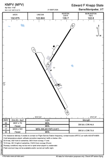


KMPV - Edward F Knapp State
Located in Barre/Montpelier, United States
ICAO - MPV, IATA - MPV
Data provided by AirmateGeneral information
Coordinates: N44°12'13" W72°33'44"
Elevation is 1165 feet MSL.
Magnetic variation is -16° East View others Airports in Vermont
Operational data
Special qualification required
Current time UTC:
Current local time:
Weather
TAF: KMPV 281732Z 2818/2918 20007KT P6SM BKN060 FM282000 24006KT P6SM VCSH BKN045 TEMPO 2820/2824 4SM SHRA BR OVC030 FM290200 31006KT P6SM SCT012 BKN022 TEMPO 2908/2912 BKN012 FM291400 34007KT P6SM BKN045
Communications frequencies: [VIEW]
Runways:
| RWY identifier | QFU | Length (ft) | Width (ft) | Surface | LDA (ft) |
| 05 | 32° | 3001 | 75 | ASPH | |
| 23 | 212° | 3001 | 75 | ASPH | |
| 17 | 152° | 5000 | 100 | ASPH | |
| 35 | 332° | 5000 | 100 | ASPH |
Airport contact information
Address: Barre/Montpelier United States
