


KMHK - Manhattan Rgnl
Located in Manhattan, United States
ICAO - MHK, IATA - MHK
Data provided by AirmateGeneral information
Coordinates: N39°8'29" W96°40'18"
Elevation is 1066 feet MSL.
Magnetic variation is 04° East View others Airports in Kansas
Operational data
Special qualification required
Current time UTC:
Current local time:
Weather
METAR: KMHK 062052Z 15015G23KT 8SM OVC014 21/18 A2956 RMK AO2 SLP004 T02060178 58039
TAF: KMHK 061720Z 0618/0718 15016G28KT P6SM BKN015 FM062300 17020G30KT P6SM VCTS OVC020CB FM070000 18020G35KT 2SM +TSRA BR BKN020CB FM070300 20007KT P6SM VCSH SCT010 BKN120
Communications frequencies: [VIEW]
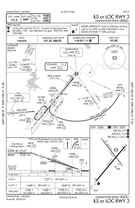
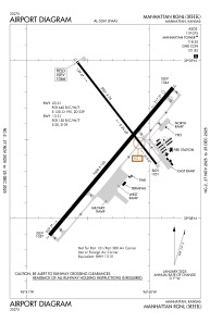
Runways:
| RWY identifier | QFU | Length (ft) | Width (ft) | Surface | LDA (ft) |
| 03 | 40° | 7400 | 150 | CONC | 7030 |
| 21 | 220° | 7400 | 150 | CONC | 7030 |
| 13 | 142° | 5001 | 75 | OTHER | 5000 |
| 31 | 322° | 5001 | 75 | OTHER | 5000 |
Airport contact information
Address: Manhattan United States
