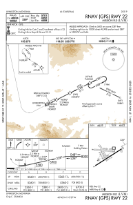
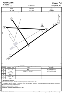


KLVM - Mission Fld
Located in Livingston, United States
ICAO - LVM, IATA - LVM
Data provided by AirmateGeneral information
Coordinates: N45°41'58" W110°26'53"
Elevation is 4659 feet MSL.
Magnetic variation is 15° East View others Airports in Montana
Operational data
Special qualification required
Current time UTC:
Current local time:
Weather
METAR: KLVM 070353Z AUTO 28024G33KT 10SM FEW090 10/M07 A2958 RMK AO2 PK WND 26040/0341 SLP004 T01001072
TAF: KLVM 062334Z 0700/0724 28027G40KT P6SM OVC060 FM071200 26032G45KT P6SM BKN100 FM071800 28022G38KT P6SM VCSH SCT015 BKN025
Communications frequencies: [VIEW]
Runways:
| RWY identifier | QFU | Length (ft) | Width (ft) | Surface | LDA (ft) |
| 04 | 54° | 5701 | 75 | ASPH | |
| 22 | 234° | 5701 | 75 | ASPH | |
| 08 | 93° | 3762 | 125 | GRASS | |
| 26 | 273° | 3762 | 125 | GRASS | |
| 13 | 147° | 2724 | 120 | GRASS | |
| 31 | 327° | 2724 | 120 | GRASS |
Airport contact information
Address: Livingston United States