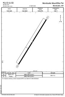


KLLQ - Monticello Muni/Ellis Fld
Located in Monticello, United States
ICAO - LLQ, IATA -
Data provided by AirmateGeneral information
Coordinates: N33°38'19" W91°45'4"
Elevation is 267 feet MSL.
Magnetic variation is 01° East View others Airports in Arkansas
Operational data
Special qualification required
Current time UTC:
Current local time:
Weather
METAR: KLLQ 292153Z AUTO 16004KT 10SM OVC080 23/17 A2989 RMK AO2 SLP119 T02280172
TAF: KLLQ 291731Z 2918/3018 19008KT P6SM VCSH OVC015 FM300000 18004KT P6SM VCTS SCT020CB OVC040 FM300400 VRB03KT P6SM OVC060 FM300800 VRB03KT 4SM BR BKN020 FM301600 06003KT P6SM SCT030
Communications frequencies: [VIEW]
Runways:
| RWY identifier | QFU | Length (ft) | Width (ft) | Surface | LDA (ft) |
| 03 | 32° | 5020 | 75 | ASPH | |
| 21 | 212° | 5020 | 75 | ASPH |
Airport contact information
Address: Monticello United States