


KLHQ - Fairfield County
Located in Lancaster, United States
ICAO - LHQ, IATA -
Data provided by AirmateGeneral information
Coordinates: N39°45'20" W82°39'26"
Elevation is 868 feet MSL.
Magnetic variation is -06° East View others Airports in Ohio
Operational data
Special qualification required
Current time UTC:
Current local time:
Weather
METAR: KLHQ 290553Z AUTO 00000KT 10SM CLR 15/13 A3005 RMK AO2 SLP168 T01500133 10250 20144 55001
Communications frequencies: [VIEW]
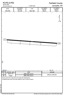
Runways:
| RWY identifier | QFU | Length (ft) | Width (ft) | Surface | LDA (ft) |
| 10 | 94° | 5003 | 75 | ASPH | |
| 28 | 274° | 5003 | 75 | ASPH |
Airport contact information
Address: Lancaster United States
