


KLAW - Lawton-Fort Sill Rgnl
Located in Lawton, United States
ICAO - LAW, IATA - LAW
Data provided by AirmateGeneral information
Coordinates: N34°34'4" W98°24'60"
Elevation is 1110 feet MSL.
Magnetic variation is 06° East View others Airports in Oklahoma
Operational data
Special qualification required
Current time UTC:
Current local time:
Weather
METAR: KLAW 291153Z AUTO 00000KT 10SM FEW120 12/11 A2991 RMK AO2 SLP120 T01220111 10161 20117 53017
TAF: KLAW 291131Z 2912/3012 VRB04KT P6SM SCT080 FM291400 14008KT P6SM SCT020
Communications frequencies: [VIEW]
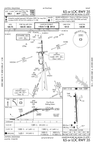
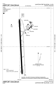
Runways:
| RWY identifier | QFU | Length (ft) | Width (ft) | Surface | LDA (ft) |
| 17 | 177° | 8599 | 150 | CONC | 8599 |
| 35 | 357° | 8599 | 150 | CONC | 8599 |
Airport contact information
Address: Lawton United States
