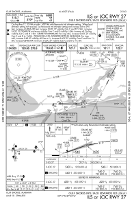
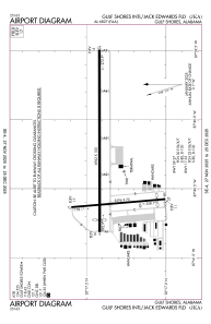


KJKA - Gulf Shores Intl/Jack Edwards Fld
Located in Gulf Shores, United States
ICAO - JKA, IATA - GUF
Data provided by AirmateGeneral information
Coordinates: N30°17'23" W87°40'18"
Elevation is 17 feet MSL.
Magnetic variation is 00° East View others Airports in Alabama
Operational data
Special qualification required
Current time UTC:
Current local time:
Weather
METAR: KJKA 291455Z 13010G19KT 9SM SCT016 BKN020 26/22 A3008
TAF: KJKA 291436Z 2915/3012 13010G20KT P6SM BKN025 FM291900 15016G22KT P6SM VCTS SCT020CB BKN040 FM300000 14009KT P6SM OVC025 FM300600 18009KT P6SM VCTS OVC015CB
Communications frequencies: [VIEW]
Runways:
| RWY identifier | QFU | Length (ft) | Width (ft) | Surface | LDA (ft) |
| 09 | 90° | 6962 | 100 | ASPH | 6500 |
| 27 | 270° | 6962 | 100 | ASPH | 6500 |
| 17 | 175° | 3596 | 75 | ASPH | 3276 |
| 35 | 355° | 3596 | 75 | ASPH | 3276 |
Airport contact information
Address: Gulf Shores United States

