


KIAG - Niagara Falls Intl
Located in Niagara Falls, United States
ICAO - IAG, IATA - IAG
Data provided by AirmateGeneral information
Coordinates: N43°6'27" W78°56'45"
Elevation is 592 feet MSL.
Magnetic variation is -10° East View others Airports in New York
Operational data
Special qualification required
Current time UTC:
Current local time:
Weather
METAR: KIAG 050153Z 17013KT 10SM BKN070 OVC090 17/09 A3002 RMK AO2 SLP166 T01720094
TAF: KIAG 042322Z 0500/0524 20010KT P6SM BKN050 FM050400 16011G18KT P6SM BKN030 FM050600 16010G17KT 6SM -SHRA BR OVC015 TEMPO 0506/0508 4SM RA BR OVC008 FM051600 19013G19KT P6SM OVC012 FM052000 21008KT P6SM OVC012 FM052300 21007KT P6SM -SHRA BKN007
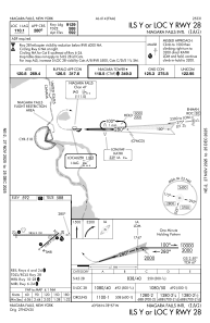
Communications frequencies: [VIEW]
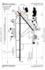
Runways:
| RWY identifier | QFU | Length (ft) | Width (ft) | Surface | LDA (ft) |
| 06 | 50° | 5188 | 150 | ASPH | 5188 |
| 24 | 230° | 5188 | 150 | ASPH | 5108 |
| 10L | 90° | 9826 | 150 | OTHER | 9129 |
| 28R | 270° | 9826 | 150 | OTHER | 9129 |
| 10R | 90° | 3972 | 78 | ASPH | 3973 |
| 28L | 270° | 3972 | 78 | ASPH | 3973 |
Airport contact information
Address: Niagara Falls United States
