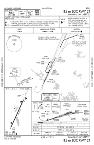
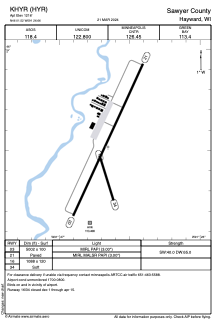


KHYR - Sawyer County
Located in Hayward, United States
ICAO - HYR, IATA - HYR
Data provided by AirmateGeneral information
Coordinates: N46°1'31" W91°26'39"
Elevation is 1216 feet MSL.
Magnetic variation is 00° East View others Airports in Wisconsin
Operational data
Special qualification required
Current time UTC:
Current local time:
Weather
METAR: KHYR 041553Z AUTO 00000KT 3SM RA BR BKN041 OVC048 08/07 A2999 RMK AO2 SLP163 P0017 T00780072
TAF: KHYR 041139Z 0412/0512 VRB03KT P6SM VCSH OVC080 FM041500 01006KT 3SM -RA OVC020 FM041900 01006KT P6SM -SHRA OVC020 FM042200 34007KT P6SM BKN045 FM051000 00000KT 6SM BR SCT250
Communications frequencies: [VIEW]
Runways:
| RWY identifier | QFU | Length (ft) | Width (ft) | Surface | LDA (ft) |
| 03 | 25° | 5002 | 100 | ASPH | |
| 21 | 205° | 5002 | 100 | ASPH | |
| 16 | 163° | 1088 | 120 | GRASS | |
| 34 | 343° | 1088 | 120 | GRASS |
Airport contact information
Address: Hayward United States
