


KHVR - Havre City-County
Located in Havre, United States
ICAO - HVR, IATA - HVR
Data provided by AirmateGeneral information
Coordinates: N48°32'35" W109°45'44"
Elevation is 2591 feet MSL.
Magnetic variation is 13° East View others Airports in Montana
Operational data
Special qualification required
Current time UTC:
Current local time:
Weather
METAR: KHVR 180153Z AUTO 30021G29KT 10SM FEW060 10/03 A2971 RMK AO2 PK WND 29030/0124 SLP063 T01000033
TAF: KHVR 172355Z 1800/1824 32015G25KT 6SM -SHRA SCT030 BKN060 TEMPO 1800/1802 VRB20G40KT 4SM -TSRA BKN035CB FM180400 27011G21KT P6SM VCSH SCT040 BKN080 FM180700 24011G19KT P6SM SCT050 BKN090 FM181400 27015G29KT P6SM FEW090 SCT200
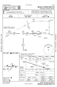
Communications frequencies: [VIEW]
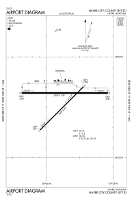
Runways:
| RWY identifier | QFU | Length (ft) | Width (ft) | Surface | LDA (ft) |
| 03 | 45° | 3699 | 60 | ASPH | 3699 |
| 21 | 225° | 3699 | 60 | ASPH | 3699 |
| 08 | 90° | 5205 | 100 | ASPH | 5205 |
| 26 | 270° | 5205 | 100 | ASPH | 5205 |
Airport contact information
Address: Havre United States