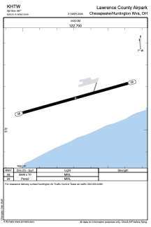


KHTW - Lawrence County Airpark
Located in Chesapeake/Huntington Wva, United States
ICAO - HTW, IATA -
Data provided by AirmateGeneral information
Coordinates: N38°25'9" W82°29'41"
Elevation is 567 feet MSL.
Magnetic variation is -05° East View others Airports in Ohio
Operational data
Special qualification required
Current time UTC:
Current local time:
Weather at : KHTS - Tri-State/Milton J Ferguson Fld ( 8 km )
METAR: KHTS 051551Z 19006KT 10SM BKN020 BKN026 24/19 A3003 RMK AO2 SLP160 T02440189 $
TAF: KHTS 051504Z 0515/0612 22005KT P6SM BKN018 FM051600 23006KT P6SM BKN025 FM051800 23006KT P6SM VCTS SCT035CB FM060000 VRB03KT P6SM BKN180 FM060600 00000KT 3SM BR BKN045
Communications frequencies: [VIEW]
Runways:
| RWY identifier | QFU | Length (ft) | Width (ft) | Surface | LDA (ft) |
| 08 | 75° | 2998 | 70 | ASPH | |
| 26 | 255° | 2998 | 70 | ASPH |
Airport contact information
Address: Chesapeake/Huntington Wva United States