


KHTS - Tri-State/Milton J Ferguson Fld
Located in Huntington, United States
ICAO - HTS, IATA - HTS
Data provided by AirmateGeneral information
Coordinates: N38°22'7" W82°33'37"
Elevation is 828 feet MSL.
Magnetic variation is -06° East View others Airports in West Virginia
Operational data
Special qualification required
Current time UTC:
Current local time:
Weather
METAR: KHTS 031651Z 10SM FEW080 27/16 A3000 RMK AO2 SLP151 T02670161
TAF: KHTS 031726Z 0318/0418 24006KT P6SM BKN080 FM032300 VRB04KT 6SM -SHRA VCTS BKN050CB FM040700 VRB03KT 6SM BR VCSH BKN035 FM041000 13002KT 4SM -RA BR OVC015
Communications frequencies: [VIEW]
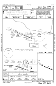
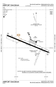
Runways:
| RWY identifier | QFU | Length (ft) | Width (ft) | Surface | LDA (ft) |
| 12 | 112° | 7017 | 150 | ASPH | 6516 |
| 30 | 292° | 7017 | 150 | ASPH | 6516 |
Airport contact information
Address: Huntington United States