


KHRT - Hurlburt Fld
Located in Mary Esther, United States
ICAO - HRT, IATA -
Data provided by AirmateGeneral information
Coordinates: N30°25'44" W86°41'20"
Elevation is 36 feet MSL.
Magnetic variation is -03° East View others Airports in Florida
Operational data
Special qualification required
Current time UTC:
Current local time:
Weather
METAR: KHRT 070355Z 15009KT 10SM FEW008 25/23 A2992 RMK AO2A SLP130 T02500228 $
TAF: TAF KHRT 070200Z 0702/0808 17006KT 9999 SCT015 QNH2988INS TEMPO 0708/0712 8000 BR BKN010 BECMG 0717/0718 18010G15KT 9999 SCT025 QNH2982INS TX28/0718Z TN23/0710Z
Communications frequencies: [VIEW]
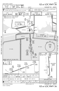
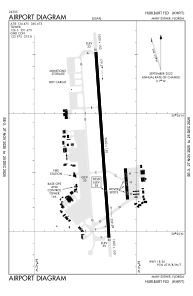
Runways:
| RWY identifier | QFU | Length (ft) | Width (ft) | Surface | LDA (ft) |
| 18 | 176° | 9600 | 150 | CONC | |
| 36 | 356° | 9600 | 150 | CONC |
Airport contact information
Address: Mary Esther United States