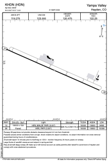


KHDN - Yampa Valley
Located in Hayden, United States
ICAO - HDN, IATA - HDN
Data provided by AirmateGeneral information
Coordinates: N40°28'52" W107°13'4"
Elevation is 6606 feet MSL.
Magnetic variation is 10° East View others Airports in Colorado
Operational data
Special qualification required
Current time UTC:
Current local time:
Weather
METAR: KHDN 061756Z AUTO 24020G27KT 10SM OVC036 01/M02 A2977 RMK AO2 PK WND 24027/1749 SLP066 60000 T00111017 10011 21011 53011 FZRANO
TAF: KHDN 061732Z 0618/0718 24016G23KT P6SM VCSH SCT025 OVC035 TEMPO 0618/0621 -SHRASN OVC027 FM062100 27023G34KT P6SM VCTS SCT025CB BKN040 TEMPO 0621/0624 3SM -TSRASN BR BKN020CB OVC028 FM070500 28010KT P6SM FEW030 SCT080 FM071300 27012G21KT 6SM -SHSN SCT035 OVC050
Communications frequencies: [VIEW]
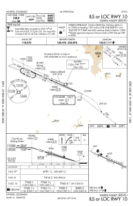
Runways:
| RWY identifier | QFU | Length (ft) | Width (ft) | Surface | LDA (ft) |
| 10 | 114° | 10000 | 150 | ASPH | 9490 |
| 28 | 294° | 10000 | 150 | ASPH | 10000 |
Airport contact information
Address: Hayden United States