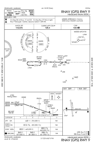
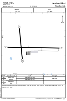


KHDL - Headland Muni
Located in Headland, United States
ICAO - HDL, IATA -
Data provided by AirmateGeneral information
Coordinates: N31°21'51" W85°18'45"
Elevation is 358 feet MSL.
Magnetic variation is -03° East View others Airports in Alabama
Operational data
Special qualification required
Current time UTC:
Current local time:
Weather at : KDHN - Dothan Rgnl ( 14 km )
METAR: KDHN 141253Z 16007KT 10SM FEW003 19/18 A2983 RMK AO2 SLP097 P0001 T01890178
TAF: KDHN 141131Z 1412/1512 20013KT P6SM -SHRA SCT006 SCT050 OVC070 FM141600 21015G20KT P6SM VCSH SCT008 BKN050 FM142000 22012KT P6SM BKN035 FM150300 22009KT P6SM BKN015
Communications frequencies: [VIEW]
Runways:
| RWY identifier | QFU | Length (ft) | Width (ft) | Surface | LDA (ft) |
| 09 | 91° | 5002 | 80 | ASPH | |
| 27 | 271° | 5002 | 80 | ASPH | |
| 17 | 175° | 2865 | 162 | GRASS | |
| 35 | 355° | 2865 | 162 | GRASS |
Airport contact information
Address: Headland United States