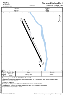


KGWS - Glenwood Springs Muni
Located in Glenwood Springs, United States
ICAO - GWS, IATA - GWS
Data provided by AirmateGeneral information
Coordinates: N39°30'22" W107°18'33"
Elevation is 5916 feet MSL.
Magnetic variation is 13° East View others Airports in Colorado
Operational data
Special qualification required
Current time UTC:
Current local time:
Weather at : KRIL - Rifle Garfield County ( 36 km )
METAR: KRIL 210953Z AUTO 19003KT 10SM OVC041 08/04 A2996 RMK AO2 SLP091 T00780039
TAF: KRIL 210540Z 2106/2206 30015G25KT P6SM -SHRA BKN060 OVC100 FM210800 27010KT 6SM -SHRA BR SCT030 BKN060 FM211400 33006KT 6SM -SHRA BR SCT030 BKN060 FM211800 30012G20KT P6SM -SHRA OVC100 FM212000 27011G21KT P6SM VCTS SCT040CB BKN070 FM220100 33009KT P6SM SCT060 BKN130
Communications frequencies: [VIEW]
Runways:
| RWY identifier | QFU | Length (ft) | Width (ft) | Surface | LDA (ft) |
| 14 | 153° | 3305 | 50 | ASPH | |
| 32 | 333° | 3305 | 50 | ASPH |
Airport contact information
Address: Glenwood Springs United States