


KRIL - Rifle Garfield County
Located in Rifle, United States
ICAO - RIL, IATA -
Data provided by AirmateGeneral information
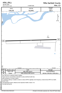
Coordinates: N39°31'36" W107°43'41"
Elevation is 5536 feet MSL.
Magnetic variation is 10° East View others Airports in Colorado
Operational data
Special qualification required
Current time UTC:
Current local time:
Weather
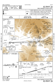
METAR: KRIL 280953Z AUTO 23007KT 10SM OVC090 05/03 A2994 RMK AO2 SLP121 T00500033
TAF: KRIL 280540Z 2806/2906 VRB03KT P6SM BKN020 OVC030 FM280900 VRB03KT P6SM SCT030 BKN045 FM281800 29010KT P6SM VCTS FEW045CB SCT070 FM290300 VRB05KT P6SM FEW045 SCT060
Communications frequencies: [VIEW]
Runways:
| RWY identifier | QFU | Length (ft) | Width (ft) | Surface | LDA (ft) |
| 08 | 88° | 7000 | 100 | ASPH | |
| 26 | 268° | 7000 | 100 | ASPH |
Airport contact information
Address: Rifle United States
