


KGRF - Gray Aaf (Joint Base Lewis-Mcchord)
Located in Fort Lewis/Tacoma, United States
ICAO - GRF, IATA - GRF
Data provided by AirmateGeneral information
Coordinates: N47°4'45" W122°34'51"
Elevation is 301 feet MSL.
Magnetic variation is 16° East View others Airports in Washington
Operational data
Special qualification required
Current time UTC:
Current local time:
Weather
METAR: KGRF 071555Z AUTO 18006KT 10SM BKN020 09/05 A3019 RMK AO2 SLP228 T00940048 $
TAF: TAF KGRF 071300Z 0713/0819 14006KT 9999 SCT040 QNH3014INS BECMG 0718/0720 27006KT 8000 -RA SCT035 BKN040 QNH3020INS BECMG 0800/0801 30004KT 9999 VCSH BKN035 OVC045 QNH3023INS BECMG 0803/0804 25003KT 9999 NSW SCT040 QNH3028INS TEMPO 0808/0813 4800 BR BECMG 0814/0815 16003KT 9999 FEW030 QNH3040INS TX14/0723Z TN03/0813Z
Communications frequencies: [VIEW]
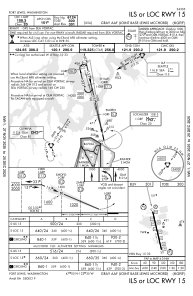
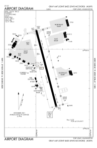
Runways:
| RWY identifier | QFU | Length (ft) | Width (ft) | Surface | LDA (ft) |
| 15 | 167° | 6124 | 150 | ASPH | |
| 33 | 347° | 6124 | 150 | ASPH | |
| H2 | 0° | 0 | 0 | UNK | |
| H3 | 0° | 0 | 0 | UNK | |
| H4 | 0° | 0 | 0 | UNK |
Airport contact information
Address: Fort Lewis/Tacoma United States