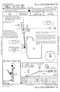
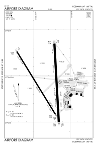


KFTK - Godman Aaf
Located in Fort Knox, United States
ICAO - FTK, IATA - FTK
Data provided by AirmateGeneral information
Coordinates: N37°54'25" W85°58'19"
Elevation is 754 feet MSL.
Magnetic variation is -03° East View others Airports in Kentucky
Operational data
Special qualification required
Current time UTC:
Current local time:
Weather
METAR: KFTK 061524Z AUTO 14004KT 10SM OVC008 20/19 A2992 RMK AO2 RAB12E21DZB21E24 OVC V BKN SLP130
TAF: TAF AMD KFTK 061456Z 0614/0717 13008KT 9999 VCTS BKN006 OVC020CB QNH2988INS TEMPO 0614/0618 18012G20KT 4800 TSRA BECMG 0617/0618 20008KT 9999 VCTS SCT010 BKN020CB OVC050 QNH2979INS TEMPO 0618/0702 23014G22KT 4800 TSRA OVC010CB BECMG 0702/0703 18006KT 9999 NSW FEW010 BKN030 QNH2976INS BECMG 0708/0709 18009KT 4800 -SHRA BR BKN010 OVC020 QNH2972INS BECMG 0712/0713 20012G22KT 9999 VCSH SCT015 OVC025 510005 QNH2967INS TX24/0621Z TN17/0711Z
Communications frequencies: [VIEW]
Runways:
| RWY identifier | QFU | Length (ft) | Width (ft) | Surface | LDA (ft) |
| 15 | 0° | 4853 | 75 | ASPH | |
| 33 | 0° | 4853 | 75 | ASPH | |
| 18 | 0° | 5184 | 150 | ASPH | |
| 36 | 0° | 5184 | 150 | ASPH |
Airport contact information
Address: Fort Knox United States