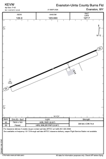


KEVW - Evanston-Uinta County Burns Fld
Located in Evanston, United States
ICAO - EVW, IATA - EVW
Data provided by AirmateGeneral information
Coordinates: N41°16'29" W111°2'5"
Elevation is 7142 feet MSL.
Magnetic variation is 13° East View others Airports in Wyoming
Operational data
Special qualification required
Current time UTC:
Current local time:
Weather
METAR: KEVW 071753Z AUTO 28015G26KT 8SM -SN FEW011 SCT025 BKN033 01/M03 A2981 RMK AO2 PK WND 27033/1724 SNE1655B48 SLP085 P0000 60002 T00111033 10017 21011 53009
TAF: KEVW 071735Z 0718/0818 28020G32KT P6SM VCSH SCT012 BKN035 TEMPO 0718/0722 1SM -SN BR BKN010 OVC035 FM080200 25010KT P6SM SCT050 SCT070 FM081600 30013G21KT P6SM BKN020 OVC040
Communications frequencies: [VIEW]
Runways:
| RWY identifier | QFU | Length (ft) | Width (ft) | Surface | LDA (ft) |
| 05 | 66° | 7300 | 100 | ASPH | |
| 23 | 246° | 7300 | 100 | ASPH |
Airport contact information
Address: Evanston United States
