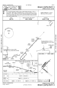
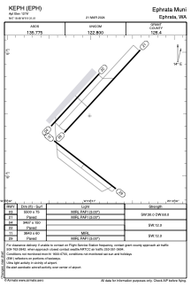


KEPH - Ephrata Muni
Located in Ephrata, United States
ICAO - EPH, IATA - EPH
Data provided by AirmateGeneral information
Coordinates: N47°18'29" W119°31'1"
Elevation is 1276 feet MSL.
Magnetic variation is 16° East View others Airports in Washington
Operational data
Special qualification required
Current time UTC:
Current local time:
Weather
METAR: KEPH 271153Z AUTO 36005KT 10SM CLR 04/02 A2988 RMK AO2 SLP121 T00390022 10122 20039 52007
Communications frequencies: [VIEW]
Runways:
| RWY identifier | QFU | Length (ft) | Width (ft) | Surface | LDA (ft) |
| 11 | 128° | 3843 | 60 | ASPH | |
| 29 | 308° | 3843 | 60 | ASPH | |
| 03 | 43° | 5500 | 75 | ASPH | |
| 21 | 223° | 5500 | 75 | ASPH | |
| 04 | 42° | 3467 | 150 | ASPH | |
| 22 | 222° | 3467 | 150 | ASPH |
Airport contact information
Address: Ephrata United States