


KENW - Kenosha Rgnl
Located in Kenosha, United States
ICAO - ENW, IATA - ENW
Data provided by AirmateGeneral information
Coordinates: N42°35'46" W87°55'38"
Elevation is 742 feet MSL.
Magnetic variation is -02° East View others Airports in Wisconsin
Operational data
Special qualification required
Current time UTC:
Current local time:
Weather
METAR: KENW 271853Z 24020G30KT 10SM BKN036 OVC045 25/17 A2984 RMK AO2 PK WND 21033/1836 SLP102 T02500167
TAF: KENW 271818Z 2718/2818 22017G32KT P6SM BKN035 FM280200 21010KT P6SM VCTS BKN035CB TEMPO 2802/2806 2SM TSRA BKN025CB FM280600 22006KT 5SM BR VCSH OVC015 FM280900 18005KT 3SM BR VCSH OVC007 FM281200 08007KT 2SM SHRA BR OVC005
Communications frequencies: [VIEW]
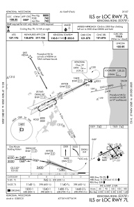
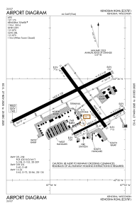
Runways:
| RWY identifier | QFU | Length (ft) | Width (ft) | Surface | LDA (ft) |
| 07R | 64° | 3302 | 75 | OTHER | |
| 25L | 244° | 3302 | 75 | OTHER | |
| 07L | 64° | 6600 | 100 | CONC | |
| 25R | 244° | 6600 | 100 | CONC | |
| 15 | 144° | 4440 | 100 | CONC | |
| 33 | 324° | 4440 | 100 | CONC |
Airport contact information
Address: Kenosha United States
