


KEGE - Eagle County Rgnl
Located in Eagle, United States
ICAO - EGE, IATA - EGE
Data provided by AirmateGeneral information
Coordinates: N39°38'34" W106°54'57"
Elevation is 6547 feet MSL.
Magnetic variation is 09° East View others Airports in Colorado
Operational data
Special qualification required
Current time UTC:
Current local time:
Weather
METAR: KEGE 061056Z AUTO 24013KT 10SM BKN120 02/M05 A2974 RMK AO2 PK WND 27026/1000 RAB15E19SNE15 SLP000 T00171050 FZRANO PNO $
TAF: KEGE 060901Z 0609/0706 22010KT P6SM -RA BKN017 OVC024 FM061000 22020G38KT 6SM -SHSN BR SCT035 OVC045 FM061200 24020G34KT 3SM -SHSN BR SCT025 BKN050 FM061600 25022G35KT P6SM VCSH SCT030 BKN040
Communications frequencies: [VIEW]
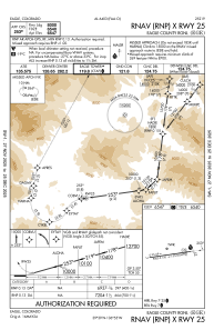
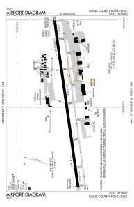
Runways:
| RWY identifier | QFU | Length (ft) | Width (ft) | Surface | LDA (ft) |
| 07 | 82° | 9000 | 150 | ASPH | 9000 |
| 25 | 262° | 9000 | 150 | ASPH | 8000 |
Airport contact information
Address: Eagle United States
