


KCXP - Carson City
Located in Carson City, United States
ICAO - CXP, IATA - CSN
Data provided by AirmateGeneral information
Coordinates: N39°11'32" W119°43'57"
Elevation is 4704 feet MSL.
Magnetic variation is 14° East View others Airports in Nevada
Operational data
Special qualification required
Current time UTC:
Current local time:
Weather
METAR: KCXP 272215Z AUTO 30012G17KT 10SM CLR 17/M02 A3003 RMK AO2
TAF: KCXP 271735Z 2718/2818 VRB05KT P6SM FEW200 FM272000 31010KT P6SM FEW050 SCT250 FM272200 28012G18KT P6SM FEW050 BKN100 FM280600 VRB03KT P6SM SCT100
Communications frequencies: [VIEW]
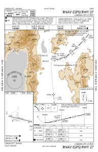
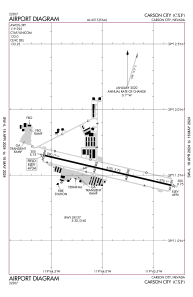
Runways:
| RWY identifier | QFU | Length (ft) | Width (ft) | Surface | LDA (ft) |
| 09 | 103° | 6101 | 75 | ASPH | |
| 27 | 283° | 6101 | 75 | ASPH |
Airport contact information
Address: Carson City United States
