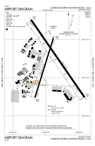


KCXO - Conroe/North Houston Rgnl
Located in Houston, United States
ICAO - CXO, IATA - CXO
Data provided by AirmateGeneral information
Coordinates: N30°21'12" W95°24'54"
Elevation is 244 feet MSL.
Magnetic variation is 05° East View others Airports in Texas
Operational data
Special qualification required
Current time UTC:
Current local time:
Weather
METAR: KCXO 020234Z AUTO 14009KT 10SM SCT018 BKN025 24/22 A2981 RMK AO2 T02390217
TAF: KCXO 012327Z 0200/0224 14012KT P6SM VCTS SCT025CB OVC060 TEMPO 0200/0201 VRB15G25KT 4SM TSRA BR BKN025CB FM020200 13012KT P6SM BKN025 FM020500 14010G20KT P6SM VCTS BKN014CB FM020900 13008KT 6SM SHRA BR VCTS OVC010CB FM021400 23009KT P6SM OVC015 FM021700 16013G22KT P6SM VCTS BKN025CB FM022100 16012G21KT P6SM BKN040
Communications frequencies: [VIEW]
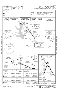
Runways:
| RWY identifier | QFU | Length (ft) | Width (ft) | Surface | LDA (ft) |
| 01 | 17° | 5000 | 100 | CONC | 5000 |
| 19 | 197° | 5000 | 100 | CONC | 5000 |
| 14 | 145° | 7501 | 150 | CONC | |
| 32 | 325° | 7501 | 150 | CONC |
Airport contact information
Address: Houston United States
