


KCLR - Cliff Hatfield Meml
Located in Calipatria, United States
ICAO - CLR, IATA - CLR
Data provided by AirmateGeneral information
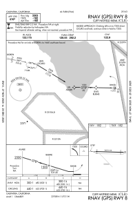
Coordinates: N33°7'53" W115°31'17"
Elevation is -181 feet MSL.
Magnetic variation is 13° East View others Airports in California
Operational data
Special qualification required
Current time UTC:
Current local time:
Weather at : KIPL - Imperial County ( 33 km )
METAR: KIPL 292253Z AUTO 07005KT 10SM CLR 33/05 A2969 RMK AO2 SLP054 T03330050 PWINO
TAF: KIPL 292320Z 3000/3024 12007KT P6SM SKC FM300300 18006KT P6SM SKC FM300600 VRB04KT P6SM SKC FM302000 12006KT P6SM SKC
Communications frequencies: [VIEW]
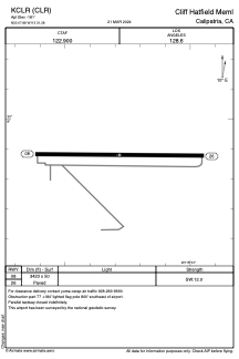
Runways:
| RWY identifier | QFU | Length (ft) | Width (ft) | Surface | LDA (ft) |
| 08 | 91° | 3423 | 50 | ASPH | |
| 26 | 271° | 3423 | 50 | ASPH |
Airport contact information
Address: Calipatria United States