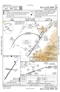
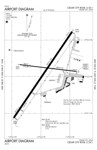


KCDC - Cedar City Rgnl
Located in Cedar City, United States
ICAO - CDC, IATA - CDC
Data provided by AirmateGeneral information
Coordinates: N37°42'3" W113°5'56"
Elevation is 5622 feet MSL.
Magnetic variation is 14° East View others Airports in Utah
Operational data
Special qualification required
Current time UTC:
Current local time:
Weather
METAR: KCDC 042053Z AUTO 19027G39KT 10SM SCT100 22/M03 A2980 RMK AO2 PK WND 18039/2047 SLP039 T02171033 57023
TAF: KCDC 041950Z 0420/0518 19021G38KT P6SM SCT080 SCT200 FM050300 22030G43KT P6SM SCT080 BKN120 FM051200 22031G45KT P6SM VCSH BKN040 OVC080
Communications frequencies: [VIEW]
Runways:
| RWY identifier | QFU | Length (ft) | Width (ft) | Surface | LDA (ft) |
| 02 | 34° | 8653 | 150 | ASPH | 8653 |
| 20 | 214° | 8653 | 150 | ASPH | 8653 |
| 08 | 97° | 4822 | 60 | ASPH | 4822 |
| 26 | 277° | 4822 | 60 | ASPH | 4822 |
Airport contact information
Address: Cedar City United States
