


KBJI - Bemidji Rgnl
Located in Bemidji, United States
ICAO - BJI, IATA - BJI
Data provided by AirmateGeneral information
Coordinates: N47°30'39" W94°56'5"
Elevation is 1391 feet MSL.
Magnetic variation is 01° East View others Airports in Minnesota
Operational data
Special qualification required
Current time UTC:
Current local time:
Weather
METAR: KBJI 280015Z AUTO 02008G14KT 10SM SCT021 OVC029 08/04 A2996 RMK AO2 T00750040
TAF: KBJI 272332Z 2800/2824 36010G20KT P6SM SCT023 OVC030 FM280300 01006KT P6SM BKN015 FM281000 05006KT P6SM BKN015 FM281900 08013KT P6SM BKN025 FM282200 08016KT P6SM BKN030
Communications frequencies: [VIEW]
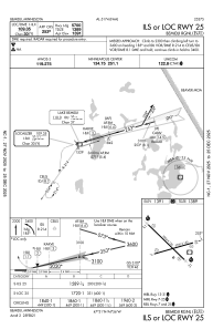
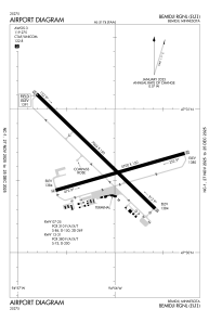
Runways:
| RWY identifier | QFU | Length (ft) | Width (ft) | Surface | LDA (ft) |
| 07 | 74° | 5700 | 150 | ASPH | 5700 |
| 25 | 254° | 5700 | 150 | ASPH | 5700 |
| 13 | 134° | 7004 | 150 | ASPH | 7002 |
| 31 | 314° | 7004 | 150 | ASPH | 7002 |
Airport contact information
Address: Bemidji United States
