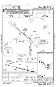
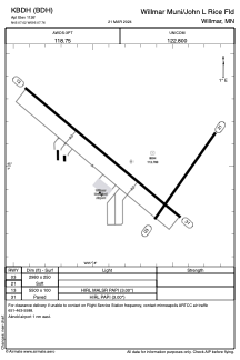


KBDH - Willmar Muni/John L Rice Fld
Located in Willmar, United States
ICAO - BDH, IATA -
Data provided by AirmateGeneral information
Coordinates: N45°7'1" W95°7'46"
Elevation is 1126 feet MSL.
Magnetic variation is 04° East View others Airports in Minnesota
Operational data
Special qualification required
Current time UTC:
Current local time:
Weather
METAR: KBDH 061015Z AUTO 12011KT 10SM OVC075 11/06 A2987 RMK AO2
Communications frequencies: [VIEW]
Runways:
| RWY identifier | QFU | Length (ft) | Width (ft) | Surface | LDA (ft) |
| 03 | 35° | 2980 | 250 | GRASS | |
| 21 | 215° | 2980 | 250 | GRASS | |
| 13 | 130° | 5500 | 100 | ASPH | |
| 31 | 310° | 5500 | 100 | ASPH |
Airport contact information
Address: Willmar United States