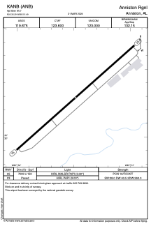


KANB - Anniston Rgnl
Located in Anniston, United States
ICAO - ANB, IATA - ANB
Data provided by AirmateGeneral information
Coordinates: N33°35'17" W85°51'29"
Elevation is 612 feet MSL.
Magnetic variation is -04° East View others Airports in Alabama
Operational data
Special qualification required
Current time UTC:
Current local time:
Weather
METAR: KANB 050353Z AUTO 00000KT 10SM BKN050 21/19 A3002 RMK AO2 SLP159 T02060194
TAF: KANB 042340Z 0500/0524 20005KT P6SM VCSH SCT070 TEMPO 0500/0502 VRB10G17KT 6SM TSRA BR BKN050CB FM050300 00000KT P6SM SCT250 FM050900 00000KT 4SM BR SCT110 FM051300 00000KT P6SM SCT150 FM051900 22006KT P6SM SCT150
Communications frequencies: [VIEW]
Runways:
| RWY identifier | QFU | Length (ft) | Width (ft) | Surface | LDA (ft) |
| 05 | 48° | 7000 | 150 | ASPH | |
| 23 | 228° | 7000 | 150 | ASPH |
Airport contact information
Address: Anniston United States
