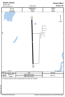


KAHH - Amery Muni
Located in Amery, United States
ICAO - AHH, IATA - AHH
Data provided by AirmateGeneral information
Coordinates: N45°16'52" W92°22'31"
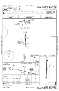
Elevation is 1087 feet MSL.
Magnetic variation is 01° East View others Airports in Wisconsin
Operational data
Special qualification required
Current time UTC:
Current local time:
Weather at : KRNH - New Richmond Rgnl ( 20 km )
METAR: KRNH 070835Z AUTO 11017G25KT 10SM SCT029 BKN120 15/07 A2949 RMK AO2 T01470066
TAF: KRNH 070539Z 0706/0806 12012G20KT P6SM BKN100 FM071000 13012G20KT 4SM -RA BR OVC020 FM071600 15010G18KT P6SM OVC025 FM071900 19010G18KT P6SM SCT040 BKN070 PROB30 0721/0803 4SM -TSRA BKN035CB FM080300 23004KT P6SM SCT100
Communications frequencies: [VIEW]
Runways:
| RWY identifier | QFU | Length (ft) | Width (ft) | Surface | LDA (ft) |
| 18 | 178° | 4000 | 75 | ASPH | |
| 36 | 358° | 4000 | 75 | ASPH |
Airport contact information
Address: Amery United States