


KAGS - Augusta Rgnl At Bush Fld
Located in Augusta, United States
ICAO - AGS, IATA - AGS
Data provided by AirmateGeneral information
Coordinates: N33°22'12" W81°57'52"
Elevation is 145 feet MSL.
Magnetic variation is -04° East View others Airports in Georgia
Operational data
Special qualification required
Current time UTC:
Current local time:
Weather
METAR: KAGS 302230Z 14007KT 10SM BKN110 23/17 A2996 RMK AO2 LTG DSNT SW T02280167
TAF: KAGS 302103Z 3021/0118 VRB05KT P6SM BKN070 TEMPO 3021/3022 -RA FM010800 00000KT 3SM BR SCT020 FM011300 35004KT P6SM FEW030
Communications frequencies: [VIEW]
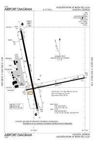
Runways:
| RWY identifier | QFU | Length (ft) | Width (ft) | Surface | LDA (ft) |
| 08 | 78° | 6002 | 75 | ASPH | |
| 26 | 258° | 6002 | 75 | ASPH | |
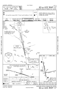
| 17 | 168° | 8001 | 150 | CONC | |
| 35 | 348° | 8001 | 150 | CONC |
Airport contact information
Address: Augusta United States
