


KACV - California Redwood Coast-Humboldt County
Located in Arcata/Eureka, United States
ICAO - ACV, IATA - ACV
Data provided by AirmateGeneral information
Coordinates: N40°58'40" W124°6'30"
Elevation is 222 feet MSL.
Magnetic variation is 17° East View others Airports in California
Operational data
Special qualification required
Current time UTC:
Current local time:
Weather
METAR: KACV 260353Z AUTO 13005KT 2 1/2SM -RA BR FEW009 OVC016 10/09 A3004 RMK AO2 SLP177 P0004 T01000094
TAF: KACV 260230Z 2603/2624 13006KT 6SM -SHRA SCT010 OVC015 TEMPO 2603/2606 2SM BR BKN007 FM260600 20010KT 2SM -SHRA BKN007 OVC015 FM261300 28007KT 5SM -SHRA BKN025 FM262200 32013KT P6SM BKN040
Communications frequencies: [VIEW]
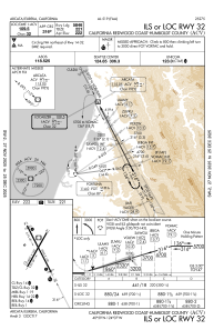
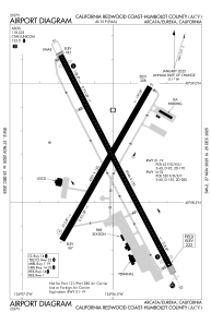
Runways:
| RWY identifier | QFU | Length (ft) | Width (ft) | Surface | LDA (ft) |
| 01 | 30° | 4501 | 150 | ASPH | 4501 |
| 19 | 210° | 4501 | 150 | ASPH | 4501 |
| 14 | 153° | 6046 | 150 | ASPH | 5601 |
| 32 | 333° | 6046 | 150 | ASPH | 5846 |
Airport contact information
Address: Arcata/Eureka United States