


F72 - Franklin Fld
Located in Franklin, United States
ICAO - F72, IATA -
Data provided by AirmateGeneral information
Coordinates: N38°18'14" W121°25'46"
Elevation is 23 feet MSL.
Magnetic variation is 16° East View others Airports in California
Operational data
Special qualification required
Current time UTC:
Current local time:
Weather at : KSAC - Sacramento Exec ( 24 km )
METAR: KSAC 262253Z 21003KT 10SM SCT110 21/05 A2989 RMK AO2 SLP120 T02060050
TAF: KSAC 262320Z 2700/2724 29009KT P6SM VCSH BKN060 BKN100 FM270400 25005KT P6SM SCT100 FM271900 30008KT P6SM SCT250
Communications frequencies: [VIEW]
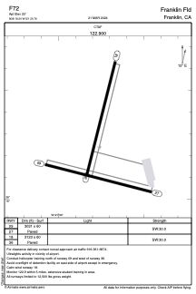
Runways:
| RWY identifier | QFU | Length (ft) | Width (ft) | Surface | LDA (ft) |
| 09 | 104° | 3031 | 60 | ASPH | |
| 27 | 284° | 3031 | 60 | ASPH | |
| 18 | 194° | 3123 | 60 | ASPH | |
| 36 | 14° | 3123 | 60 | ASPH |
Airport contact information
Address: Franklin United States