


D58 - Timber Lake Muni
Located in Timber Lake, United States
ICAO - D58, IATA -
Data provided by AirmateGeneral information
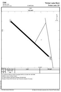
Coordinates: N45°24'54" W101°4'60"
Elevation is 2193 feet MSL.
Magnetic variation is 10° East View others Airports in South Dakota
Operational data
Special qualification required
Current time UTC:
Current local time:
Weather at : KMBG - Mobridge Muni ( 55 km )
METAR: KMBG 180122Z AUTO 35027G51KT 9SM VCTS SCT090 SCT110 19/11 A2940 RMK AO2 PK WND 36051/0119 LTG DSNT NW-NE T01940106
TAF: KMBG 172324Z 1800/1824 19013G22KT P6SM VCSH FEW090 SCT240 FM180100 22013G23KT 6SM SHRA BR VCTS SCT080CB BKN150 FM180200 30014G22KT 6SM SHRA BR SCT015 BKN150 FM180900 33021G33KT P6SM SCT210 FM182200 29018G25KT P6SM FEW210
Communications frequencies: [VIEW]
Runways:
| RWY identifier | QFU | Length (ft) | Width (ft) | Surface | LDA (ft) |
| 12 | 0° | 3300 | 150 | GRASS | |
| 30 | 0° | 3300 | 150 | GRASS |
Airport contact information
Address: Timber Lake United States