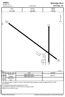


KMBG - Mobridge Muni
Located in Mobridge, United States
ICAO - MBG, IATA - MBG
Data provided by AirmateGeneral information
Coordinates: N45°32'47" W100°24'23"
Elevation is 1716 feet MSL.
Magnetic variation is 09° East View others Airports in South Dakota
Operational data
Special qualification required
Current time UTC:
Current local time:
Weather
METAR: KMBG 282352Z AUTO 03010KT 10SM -RA BKN014 BKN024 OVC048 06/03 A2985 RMK AO2 SLP118 P0001 60012 T00610033 10072 20061 58005
TAF: KMBG 282324Z 2900/2924 05011KT P6SM -RA OVC015 FM290200 36007KT 4SM -RA BR OVC007 FM291300 32006KT P6SM OVC007 FM291800 33008KT P6SM OVC015 FM292200 08007KT P6SM OVC050
Communications frequencies: [VIEW]
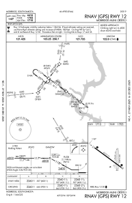
Runways:
| RWY identifier | QFU | Length (ft) | Width (ft) | Surface | LDA (ft) |
| 12 | 127° | 4410 | 75 | ASPH | |
| 30 | 307° | 4410 | 75 | ASPH | |
| 17 | 180° | 2399 | 250 | GRASS | |
| 35 | 360° | 2399 | 250 | GRASS |
Airport contact information
Address: Mobridge United States
