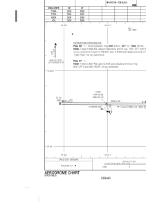


CZGI - Gods River
Located in , Canada
ICAO - CZGI, IATA - ZGI
Data provided by AirmateGeneral information
Coordinates: N54°50'23" W94°4'43"
Elevation is 627 feet MSL.
Magnetic variation is -0.7992° East View others Airports in Manitoba
Operational data
Special qualification required
Current time UTC:
Current local time:
Weather at : - ( 0 km )
METAR: CYBU 180937Z AUTO 23008KT 9SM BKN008 BKN013 OVC024 10/09 A2944 RMK SLP983 DENSITY ALT 1500FT
Communications frequencies: [VIEW]
Runways:
| RWY identifier | QFU | Length (ft) | Width (ft) | Surface | LDA (ft) |
| 09 | 90° | 3532 | 80 | GRAVE | 3532 |
| 27 | 270° | 3532 | 80 | GRAVE | 3532 |
Airport contact information
Address: Canada