


CYJN - St-Jean
Located in St Jean, Canada
ICAO - CYJN, IATA - YJN
Data provided by AirmateGeneral information
Coordinates: N45°17'40" W73°16'54"
Elevation is 136 feet MSL.
Magnetic variation is -14.90° East View others Airports in Quebec
Operational data
Special qualification required
Current time UTC:
Current local time:
Weather at : CYHU - St-Hubert ( 27 km )
METAR: CYHU 120400Z AUTO 13010G15KT 9SM OVC066 14/07 A2978 RMK SLP088
TAF: TAF CYHU 112340Z 1200/1224 12006KT P6SM BKN080 TEMPO 1200/1206 FEW080 BECMG 1201/1203 13005KT FM120600 17008KT P6SM BKN050 FM120900 13008KT P6SM BKN030 BKN100 FM121600 05005KT P6SM FEW050 BKN160 FM122000 05005KT P6SM FEW050 FEW200 RMK FCST BASED ON AUTO OBS. NXT FCST BY 120600Z
Communications frequencies: [VIEW]
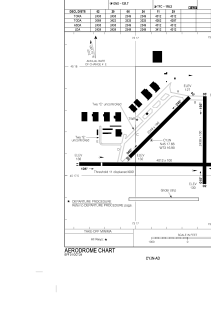
Runways:
| RWY identifier | QFU | Length (ft) | Width (ft) | Surface | LDA (ft) |
| 02 | 0° | 2438 | 100 | ASPH | 2438 |
| 20 | 180° | 2438 | 100 | ASPH | 2438 |
| 06 | 45° | 2349 | 100 | ASPH | 2349 |
| 24 | 225° | 2349 | 100 | ASPH | 2349 |
| 11 | 90° | 4012 | 100 | ASPH | 3412 |
| 29 | 270° | 4012 | 100 | ASPH | 4012 |
Airport contact information
Address: St Jean Canada