


CYCO - Kugluktuk
Located in , Canada
ICAO - CYCO, IATA - YCO
Data provided by AirmateGeneral information
Coordinates: N67°49'0" W115°8'38"
Elevation is 74 feet MSL.
Magnetic variation is 15.9705° East View others Airports in Nunavut
Operational data
Special qualification required
Current time UTC:
Current local time:
Weather
METAR: CYCO 221500Z 04004KT 6SM BR BKN004 BKN012 00/M01 A3010 RMK SF7SC1 SC TR CIG RAG SLP196
TAF: TAF AMD CYCO 221417Z 2214/2301 03005KT 6SM BR SCT004 BKN012 TEMPO 2214/2217 1 1/2SM BR BKN004 FM221700 06010KT P6SM SCT012 TEMPO 2217/2219 2SM BR BKN004 FM221900 06010KT P6SM FEW008 RMK NXT FCST BY 221900Z
Communications frequencies: [VIEW]
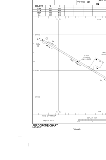
Runways:
| RWY identifier | QFU | Length (ft) | Width (ft) | Surface | LDA (ft) |
| 12 | 121° | 5502 | 100 | GRAVE | 5502 |
| 30 | 301° | 5502 | 100 | GRAVE | 5502 |
Airport contact information
Address: Canada