


CSU3 - St-Hyacinthe
Located in , Canada
ICAO - CSU3, IATA -
Data provided by AirmateGeneral information
Coordinates: N45°36'24" W73°0'54"
Elevation is 118 feet MSL.
Magnetic variation is -16° East View others Airports in Quebec
Operational data
Special qualification required
Current time UTC:
Current local time:
Weather at : CYHU - St-Hubert ( 33 km )
METAR: CYHU 130900Z AUTO 16003KT 9SM FEW042 SCT055 OVC110 10/09 A2994 RMK SLP142
TAF: TAF CYHU 130540Z 1306/1406 16007KT P6SM BKN110 TEMPO 1306/1311 5SM BR FM131400 17010KT P6SM BKN060 OVC100 FM131700 17015KT P6SM -SHRA BKN050 OVC080 FM132200 17010KT P6SM -SHRA BKN020 OVC040 RMK FCST BASED ON AUTO OBS. NXT FCST BY 131200Z
Communications frequencies: [VIEW]
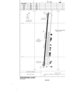
Runways:
| RWY identifier | QFU | Length (ft) | Width (ft) | Surface | LDA (ft) |
| 02 | 5° | 3823 | 75 | ASP+GRS | 3397 |
| 20 | 185° | 3823 | 75 | ASP+GRS | 3469 |
Airport contact information
Address: Canada
