


9D9 - Hastings
Located in Hastings, United States
ICAO - 9D9, IATA -
Data provided by AirmateGeneral information
Coordinates: N42°39'48" W85°20'45"
Elevation is 800 feet MSL.
Magnetic variation is -06° East View others Airports in Michigan
Operational data
Special qualification required
Current time UTC:
Current local time:
Weather at : KGRR - Gerald R Ford Intl ( 28 km )
TAF: KGRR 271324Z 2713/2812 19016G26KT P6SM SCT030 BKN045 TEMPO 2714/2717 BKN030 FM271800 22017G31KT P6SM BKN035 FM280000 22013G23KT P6SM BKN070 FM280600 22011G21KT P6SM -SHRA BKN018
Communications frequencies: [VIEW]
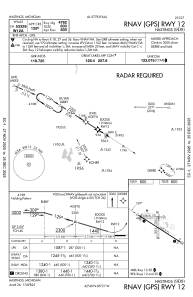
Runways:
| RWY identifier | QFU | Length (ft) | Width (ft) | Surface | LDA (ft) |
| 09 | 87° | 2380 | 170 | GRASS | |
| 27 | 267° | 2380 | 170 | GRASS | |
| 12 | 122° | 5003 | 75 | ASPH | |
| 30 | 302° | 5003 | 75 | ASPH | |
| 18 | 179° | 1952 | 200 | GRASS | |
| 36 | 359° | 1952 | 200 | GRASS |
Airport contact information
Address: Hastings United States