


68F - Teague Muni
Located in Teague, United States
ICAO - 68F, IATA -
Data provided by AirmateGeneral information
Coordinates: N31°39'42" W96°18'38"
Elevation is 525 feet MSL.
Magnetic variation is 06° East View others Airports in Texas
Operational data
Special qualification required
Current time UTC:
Current local time:
Weather at : KLXY - Mexia-Limestone County ( 19 km )
METAR: KLXY 290955Z AUTO 24003KT 3/4SM BR BKN002 17/17 A2983 RMK AO2 LTG DSNT SE T01710169
Communications frequencies: [VIEW]
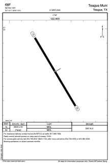
Runways:
| RWY identifier | QFU | Length (ft) | Width (ft) | Surface | LDA (ft) |
| 15 | 149° | 3300 | 50 | ASPH | |
| 33 | 329° | 3300 | 50 | ASPH |
Airport contact information
Address: Teague United States