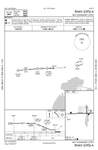


57D - Ray Community
Located in Ray, United States
ICAO - 57D, IATA -
Data provided by AirmateGeneral information
Coordinates: N42°44'12" W82°53'20"
Elevation is 632 feet MSL.
Magnetic variation is -06° East View others Airports in Michigan
Operational data
Special qualification required
Current time UTC:
Current local time:
Weather at : KMTC - Selfridge Angb ( 14 km )
METAR: KMTC 051215Z 00000KT 1/4SM R19/4000FT FG BKN001 17/16 A2988 RMK AO2A SLP122 $
TAF: TAF KMTC 051100Z 0511/0617 VRB06KT 0400 FG OVC003 QNH2985INS TEMPO 0511/0513 1600 BR BECMG 0514/0515 VRB06KT 9000 -RA OVC030 QNH2993INS BECMG 0517/0518 VRB06KT 9999 NSW SKC QNH2999INS TX20/0515Z TN07/0611Z
Communications frequencies: [VIEW]
Runways:
| RWY identifier | QFU | Length (ft) | Width (ft) | Surface | LDA (ft) |
| 01 | 359° | 2202 | 123 | OTHER | |
| 19 | 179° | 2202 | 123 | OTHER | |
| 10 | 88° | 2495 | 60 | ASPH | |
| 28 | 268° | 2495 | 60 | ASPH |
Airport contact information
Address: Ray United States
