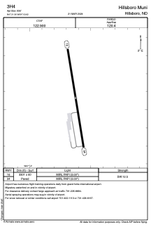


3H4 - Hillsboro Muni
Located in Hillsboro, United States
ICAO - 3H4, IATA -
Data provided by AirmateGeneral information
Coordinates: N47°21'34" W97°3'37"
Elevation is 906 feet MSL.
Magnetic variation is 05° East View others Airports in North Dakota
Operational data
Special qualification required
Current time UTC:
Current local time:
Weather at : KFAR - Hector Intl ( 52 km )
METAR: KFAR 061153Z 12014KT 10SM OVC070 14/06 A2979 RMK AO2 SLP088 T01390056 10144 20122 56017
TAF: KFAR 061131Z 0612/0712 14016G24KT P6SM SKC FM061600 14027G38KT P6SM BKN120 FM070700 13025G38KT P6SM -SHRA OVC020
Communications frequencies: [VIEW]
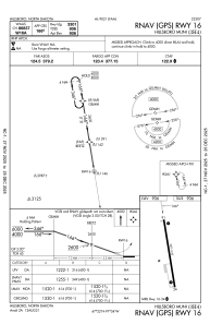
Runways:
| RWY identifier | QFU | Length (ft) | Width (ft) | Surface | LDA (ft) |
| 16 | 171° | 3301 | 60 | CONC | |
| 34 | 351° | 3301 | 60 | CONC |
Airport contact information
Address: Hillsboro United States