


1RL - Point Roberts Airpark
Located in Point Roberts, United States
ICAO - 1RL, IATA -
Data provided by AirmateGeneral information
Coordinates: N48°58'38" W123°4'45"
Elevation is 11 feet MSL.
Magnetic variation is 19° East View others Airports in Washington
Operational data
Special qualification required
Current time UTC:
Current local time:
Weather at : CYVR - Vancouver Intl ( 25 km )
METAR: CYVR 061022Z 12007KT 20SM FEW019 SCT039 BKN084 08/08 A2976 RMK SC2SC2AC2 SLP080
TAF: TAF CYVR 060840Z 0609/0712 13012KT P6SM SCT020 BKN050 TEMPO 0609/0614 P6SM -SHRA BKN020 OVC050 BECMG 0612/0614 24008KT FM061400 24010KT P6SM FEW020 BKN040 TEMPO 0621/0706 P6SM -SHRA FM070600 29010KT P6SM SCT020 BKN070 RMK NXT FCST BY 061200Z
Communications frequencies: [VIEW]
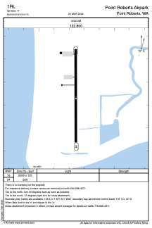
Runways:
| RWY identifier | QFU | Length (ft) | Width (ft) | Surface | LDA (ft) |
| 16 | 180° | 2265 | 125 | GRASS | |
| 34 | 360° | 2265 | 125 | GRASS |
Airport contact information
Address: Point Roberts United States