


16FL - J-22 Ranch
Located in Milton, United States
ICAO - 16FL, IATA -
Data provided by AirmateGeneral information
Coordinates: N30°43'32" W87°12'3"
Elevation is 200 feet MSL.
Magnetic variation is -03° East View others Airports in Florida
Operational data
Special qualification required
Current time UTC:
Current local time:
Weather at : KNSE - Whiting Fld Nas North ( 17 km )
METAR: KNSE 220956Z AUTO 00000KT 6SM BR CLR 18/17 A2997 RMK AO2 SLP134 T01780167 $
TAF: TAF KNSE 2207/2307 VRB06KT 9999 FEW060 QNH2991INS TEMPO 2208/2212 4800 BR SCT004 FM221500 VRB06KT 9999 SCT040 SCT150 BKN250 QNH2997INS FM221900 18008G15KT 9999 FEW040 SCT060 SCT150 BKN250 QNH2993INS FM230100 VRB06KT 9999 SCT250 QNH2993INS AUTOMATED SENSOR METWATCH 2207 TIL 2211 TX30/2219Z TN18/2209Z FN00274
Communications frequencies: [VIEW]
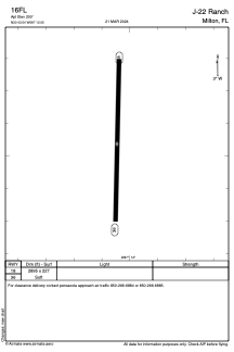
Runways:
| RWY identifier | QFU | Length (ft) | Width (ft) | Surface | LDA (ft) |
| 18 | 0° | 2895 | 227 | GRASS | |
| 36 | 0° | 2895 | 227 | GRASS |
Airport contact information
Address: Milton United States
