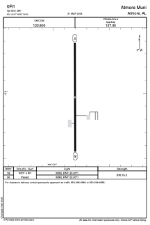


0R1 - Atmore Muni
Located in Atmore, United States
ICAO - 0R1, IATA -
Data provided by AirmateGeneral information
Coordinates: N31°0'58" W87°26'48"
Elevation is 286 feet MSL.
Magnetic variation is -03° East View others Airports in Alabama
Operational data
Special qualification required
Current time UTC:
Current local time:
Weather at : KNSE - Whiting Fld Nas North ( 52 km )
METAR: KNSE 080456Z AUTO 18004KT 8SM FEW012 23/22 A2987 RMK AO2 SLP099 T02330222 $
TAF: TAF KNSE 0723/0823 17009KT 9999 FEW020 SCT035 SCT250 QNH2982INS BECMG 0806/0808 18005KT 8000 BR FEW005 SCT020 SCT250 QNH2981INS TEMPO 0808/0812 3200 BR SCT003 BKN015 FM081300 19008KT 9999 SCT020 BKN250 QNH2985INS FM081500 20013G23KT 9999 SCT030 SCT060 BKN250 QNH2984INS FM082100 20010G18KT 9999 FEW035 SCT060 SCT250 QNH2981INS AUTOMATED SENSOR METWATCH 0804 TIL 0811 TX30/0819Z TN22/0809Z FN20029
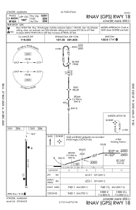
Communications frequencies: [VIEW]
Runways:
| RWY identifier | QFU | Length (ft) | Width (ft) | Surface | LDA (ft) |
| 18 | 180° | 5001 | 80 | ASPH | |
| 36 | 360° | 5001 | 80 | ASPH |
Airport contact information
Address: Atmore United States