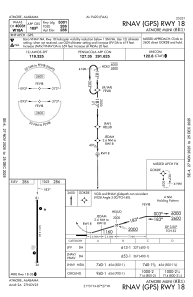
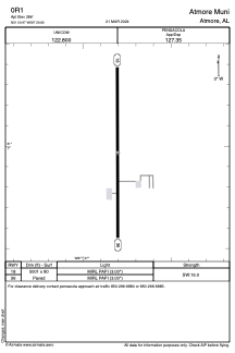


0R1 - Atmore Muni
Located in Atmore, United States
ICAO - 0R1, IATA -
Data provided by AirmateGeneral information
Coordinates: N31°0'58" W87°26'48"
Elevation is 286 feet MSL.
Magnetic variation is -03° East View others Airports in Alabama
Operational data
Special qualification required
Current time UTC:
Current local time:
Weather at : KNSE - Whiting Fld Nas North ( 52 km )
METAR: KNSE 282256Z 14012KT 10SM FEW040 FEW080 SCT200 25/16 A3009 RMK AO2 SLP175 T02500161 $
TAF: TAF KNSE 2823/2923 17016G22KT 9999 SKC QNH2998INS BECMG 2907/2909 12008KT 9999 SCT015 QNH3000INS BECMG 2915/2917 16012G20KT 9999 SCT050 QNH2999INS TX29/2919Z TN17/2907Z FN00264
Communications frequencies: [VIEW]
Runways:
| RWY identifier | QFU | Length (ft) | Width (ft) | Surface | LDA (ft) |
| 18 | 180° | 5001 | 80 | ASPH | 4506 |
| 36 | 360° | 5001 | 80 | ASPH | 4506 |
Airport contact information
Address: Atmore United States