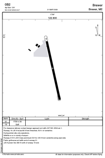


0B2 - Brewer
Located in Brewer, United States
ICAO - 0B2, IATA -
Data provided by AirmateGeneral information
Coordinates: N44°45'50" W68°46'4"
Elevation is 125 feet MSL.
Magnetic variation is -19° East View others Airports in Maine
Operational data
Special qualification required
Current time UTC:
Current local time:
Weather at : KBGR - Bangor Intl ( 7 km )
METAR: KBGR 281253Z 18011KT 10SM SCT100 BKN140 BKN200 12/03 A3019 RMK AO2 SLP222 T01170028
TAF: KBGR 281120Z 2812/2912 17008KT P6SM SCT110 BKN220 FM281400 18010G18KT P6SM BKN090 FM282300 18006KT P6SM VCSH BKN035 FM290000 18006KT P6SM VCSH BKN028 FM290800 32005KT P6SM SCT040
Communications frequencies: [VIEW]
Runways:
| RWY identifier | QFU | Length (ft) | Width (ft) | Surface | LDA (ft) |
| 01 | 348° | 1730 | 30 | GRASS | |
| 19 | 168° | 1730 | 30 | GRASS |
Airport contact information
Address: Brewer United States