


S75 - Payette Muni
Located in Payette, United States
ICAO - S75, IATA -
Data provided by AirmateGeneral information
Coordinates: N44°5'38" W116°54'11"
Elevation is 2230 feet MSL.
Magnetic variation is 17° East View others Airports in Idaho
Operational data
Special qualification required
Current time UTC:
Current local time:
Weather at : KONO - Ontario Muni ( 12 km )
METAR: KONO 080753Z AUTO 28009KT 10SM -RA FEW120 24/11 A2987 RMK AO2 SLP093 P0000 T02440111
TAF: KONO 080621Z 0806/0906 31005KT P6SM SCT150 TEMPO 0807/0809 VRB20G30KT 5SM -SHRA OVC050 FM081700 36007KT P6SM BKN200
Communications frequencies: [VIEW]
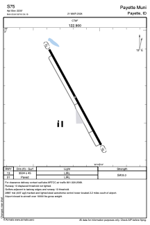
Runways:
| RWY identifier | QFU | Length (ft) | Width (ft) | Surface | LDA (ft) |
| 13 | 0° | 3534 | 45 | ASPH | |
| 31 | 0° | 3534 | 45 | ASPH |
Airport contact information
Address: Payette United States